Estuaries are semi-enclosed bodies of water where saltwater from the sea mixes with freshwater flowing from the land.
Estuaries are a product of the landscape and climate in which they are located, the freshwater flows they receive, and the energy and input from the coastal waters and prevailing winds. They include a diverse range of habitats that are defined partly by the timing and amount of fresh and saltwater flowing into them and the physical size and shape of the estuary and its floodplain.
Estuaries are dynamic systems that provide significant environmental, social and economic values to local communities, including important culturally significant places for Aboriginal people.
When an estuary closes, flooding of boat ramps, jetties and adjoining land may occur.
The estuaries of the Gippsland coast are susceptible to entrance closure caused by sand build-up at the point where the estuary meets the open sea. Depending on the freshwater inflows, estuary shape, floodplain and sea conditions the entrance can remain closed for between months and years.
These closures are natural events that have the effect of reducing the influence of seawater in the estuary. Later, as freshwater flows into the estuary following rain events, water levels rise and adjoining low lying land can get flooded.
The pooling of water can impact on farmland and built infrastructure. The flooding can also inundate areas suitable for bird nesting. Conversely, the flooding also inundates areas suitable for fish spawning and some bird species and enhances aquatic habitats.
Estuary Opening Fact Sheet can be found here.
Natural Openings
A closed estuary will eventually open, normally as a result of high river flows which raise the water level to a point where it flows over the estuary berm, scouring a channel and creating an outlet to the sea.
The Authority prefers that a natural opening takes place as most often these result in a better entrance scour and a longer-lasting entrance.
Artificial openings
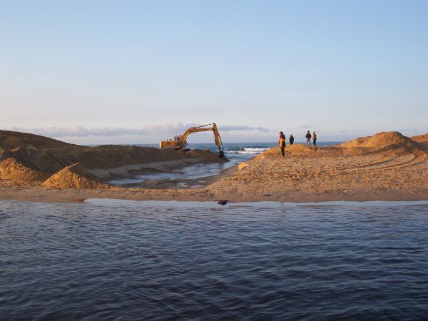
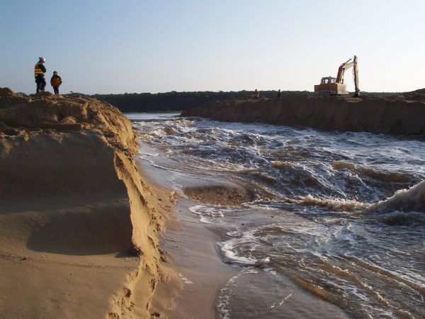
An artificial opening is defined as the opening of the estuary by manually creating a channel to the sea. The channel, whilst small at first, rapidly increases in size due to the erosion initiated by high velocity flows through the channel as the estuary drains.
Without a sufficient hydraulic gradient – i.e. the differential between the water level in the estuary and the sea level – the entrance of the estuary can fail to open successfully as the erosion and the size of the channel is insufficient to maintain the outflow and wave action pushes sand back into the excavated channel.
Water height levels are found on Victoria’s Water Measurement Information System | WMIS Site. These measurements are taken from a gauge located at estuary sites including Lake Tyers, Marlo, Sydenham and Mallacoota. Other Data is collected including salinity, stream water level and water temperature.
There are a number of variables that can influence an opening. These include:
- The height differential between the estuary water level and the sea (the more the better).
- The distance across the sand berm which affects the gradient of the channel and the volume of sand to be mobilised.
- Sea conditions, where large waves can move sand into the entrance forcing a rapid closure, and
- Catchment inflows, where a higher inflow will increase that the likelihood the entrance will remain open for longer.
In the right conditions, an artificial opening can maintain an entrance open to the sea for a considerable period of time. If undertaken when the conditions are not suitable the entrance may not successfully open or could close again in a matter of days or weeks.
Choosing a suitable location to initiate the opening may also influence the duration and success of the opening.
Risks associated with an artificial opening
There are risks to the ecological values of the estuary that require consideration before an opening is attempted. These include:
- Leaving the estuary with de-oxygenated water that can lead to fish deaths.
- Reducing the available habitat for spawning fish.
- The loss of bird breeding habitat.
There are also ecological risks associated with not opening an estuary that include:
- Flooding of bird breeding habitat.
- Inability of migratory aquatic species to enter or leave the estuary.
- Loss of foraging habitat for some bird species.
- Dieback of vegetation not tolerant of inundation.
There are also personal and property risks to the community. When water is flowing through the entrance, a significant difference in the level of water over a short distance creates high water velocities. Erosion also creates unstable sand cliffs along the channel margins that are prone to collapse. Strong currents can exist in the estuary hundreds of metres from the entrance. The mooring lines on boats may need to be adjusted periodically as the water rapidly recedes.
Another risk, after the estuary has effectively drained, is the remaining sand cliffs that are prone to collapse.
Legislative context
The East Gippsland Catchment Management Authority authorises the opening through a permit administered under the Water Act 1989 and sets the conditions under which the entrance will be opened.
Historically the opening decision, management and costs have been borne by the land manager at the entrance.
In October 2010 the federal court made a determination (FCA1144) that native title exists over much of Gippsland and is held by the Gunaikurnai people. The court recognised the Gunaikurnai Land and Waters Aboriginal Corporation (GLaWAC) as the sole holder and representative body of these native title rights and interests on behalf of all Gunaikurnai people. GLaWAC is also the appointed Registered Aboriginal Party (RAP) under the Aboriginal Heritage Act 2006 for the Gunaikurnai native title area. The Gunaikurnai RAP sets any conditions and requirements for the protection and management of Aboriginal heritage under the Aboriginal Heritage Act 2006 when opening the Lake Tyers and Snowy River estuaries.
For the estuaries further east – Sydenham and Mallacoota – the Office of Aboriginal Affairs Victoria (AAV) has responsibilities under the Aboriginal Heritage Act 2006 for the protection and management of Aboriginal heritage.
Agencies involved in estuary management
The East Gippsland CMA is the lead agency regarding the artificial opening of estuaries in East Gippsland. The CMA has formal arrangements with the other agencies with defined roles and responsibilities in estuary management including;
East Gippsland CMA (lead organisation – planning)
Parks Victoria (lead organisation – works)
Aboriginal Affairs Victoria (Mallacoota Inlet and Sydenham Inlet)
Gunaikurnai Land and Waters Aboriginal Corporation (Snowy River and Lake Tyers)
Environmental Protection Authority
Department of Environment, Land, Water and Planning
Dredging as an Option
Maintaining a permanently open entrance via dredging at Mallacoota Inlet, Sydenham Inlet, the Snowy River estuary at Marlo and at Lake Tyers would be cost-prohibitive.